Arles | Van Gogh

As we were traveling from southern Spain en route to Italia, we planned a short layover in Arles, France.  What is in Arles, you ask?  I had no idea, really, except that I read there was an ancient Roman arena, and Van Gogh spent extensive time there.  Well, I was pleasantly surprised by this beautiful little city.  This post focuses on the Van Gogh aspect of the town.

This is a very artistic town with several art museums, including one dedicated to Van Gogh.  Unfortunately, we didn’t make it into any of the museums because it was a bang-bang two night stay, but we made sure we did The Van Gogh Trail.  Van Gogh spent much time in Arles, which is the town where he happened to cut off part of his ear and home of the mental institution in which he was treated.  During his time here, he painted at least one painting every day.  The Van Gogh Trail takes you on a walking journey through the city to see the spot where he laid his easel and painted some of his notable works.  A handy brochure is available at the tourist office, which contains a map and a list of the works.  It also assists the sidewalk markers considerably, which were great but a little far and in between at times.  Each location is marked with a lectern-style signage with an image and short background of the painting.

Our first stop was at the location of probably his most famous Arles work, Le Cafe Le Soir.  The city did a great job preserving the appearance of the building in the painting – the original wall and awning were not yellow, that’s just how Van Gogh saw the lighting from the cafe.  It’s also a bit ironic that Vincent was actually sitting at the cafe across the tiny alley while he painted this scene, but the yellow cafe was able to cash-in on the tourist value (we were told to avoid it, so we did).

We did the rest of the tour on our own route and schedule, plus I’ve reordered the images for formatting purposes, but we were able to hit 9/10 spots.  We were told the bridge at number 10 no longer exists so we didn’t bother trekking over there.

The public garden had two entrances that we thought were possible influences on this painting.  The central entry is the “official” entry with the signage, but I thought the east entry was more representative of the painting.  The central entry has benches and the curved right-hand stone wall, but the east entry had much more accurate trees (conifers on either side, and the central tree near the sidewalk split) – maybe Van Gogh sat at both entries to draw his inspiration?

We walked along the river to this location during the day, and found a big tour boat blocking the view.  I snapped a picture and said I would come back later at night.  Well, I did, but the boat was still there.  Stupid boat.

The mental institution where Van Gogh stayed after his ear incident was in the center of town.  The public is able to access the appropriately named public garden, which is flanked by two gift-shops, which are directly behind the camera.  Van Gogh must have been on the balcony, which unfortunately we were not able to access (we tried).

The Roman arena still holds events today, and Van Gogh attended one as he rendered this painting.  I can’t say for sure it’s the same spot because there wasn’t a lectern at this location, but it’s the same arena and a pretty darn close perspective.

We actually walked by the yellow house on our way from the train station upon our arrival without realizing, but we soon found it again on the walking tour.  The yellow house is no longer there but the building behind is nearly exactly the same.

The bridge is still there but not with the same overhead structure.  My favorite part of this location is comparing the baby tree in the painting to the fully grown tree today.

This location was the first that we actually weren’t able to access – you had to pay an admission fee to the Alyscamps.  It was a very small fee (3 euros, I think), but it was getting late in the day and we had several pieces of art to go, so we took a shot from the entry as far as I could muster away from the front gate attendant without getting in trouble.  However, you can see the same white stone arch that Van Gogh painted while he sat just inside the park to the right.

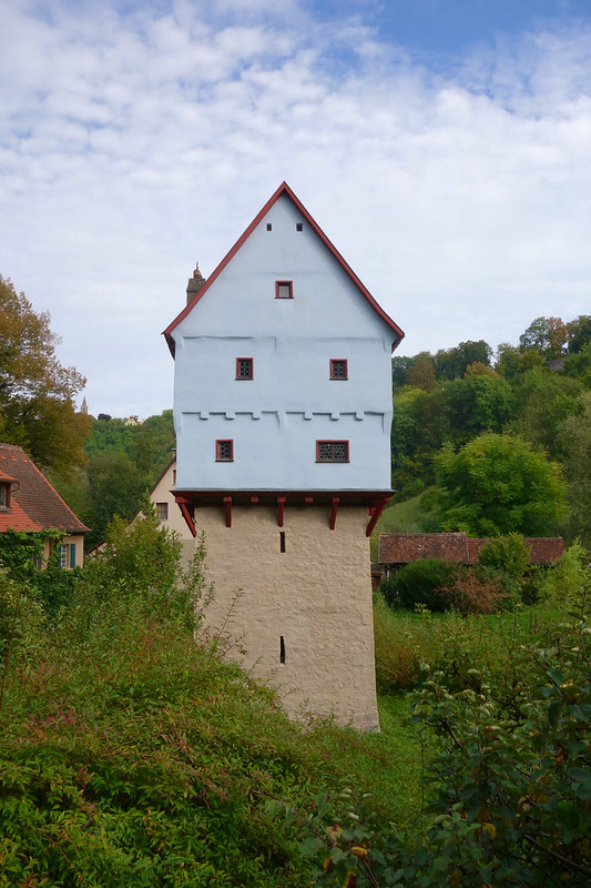
This location was probably the most disappointing because it didn’t do the painting justice.  We made our way to the east part of town across the train tracks and were in search of the lectern.  The sidewalk markers stopped after the bridge, and we were lost searching for the location of that old easel.  After circling the block several times, checking the map countless times, and draining the battery on our phones, the closest thing we could find to the old mill was this house.  The house is a different proportion and there’s no more creak, but the off-centered gable roof, chimney, single window, and small canopy convinced me this must be it.

That concludes our tour of Van Gogh.  This was definitely one of my favorite things to do on our entire trip, being able to sit in the exact same spot looking at the same backdrops one of the most influential artists ever thought was inspiring enough to paint.  Beauty truly can be anywhere, so it’s no wonder Van Gogh spent so much time in the beautiful city of Arles.

Neuschwanstein Castle

Our Swiss utopia came to an end and our journey brought us back to Bavaria. We headed to Fussen, which is in southern Germany and straddles the border to Austria. It also happens to be the home of the famous Mad King Ludwig. Ludwig lived in this beautiful region as a child in Hohenschwangau Castle and dreamed of one day building his own fairy-tale castle in the same hills. When he became King he built himself a castle, Neuschwanstein.

When we arrived at the castle it definitely felt like a classic children’s cartoon. From the rolling hills to the dense forest to the trickling water falls, it seemed like the perfect make-believe setting. We could see how good ol’ Walt used it as his inspiration for Cinderella’s Castle.

We took a tour of the castle’s interior, which was just as impressive as the exterior. Every square inch of the walls and ceilings were covered in either intricately painted scenes or decoratively carved wood – at least in the completed rooms. The maginificent castle contains 64 rooms, but only 16 were ever finished before King Ludwig mysteriously passed away (or perhaps was murdered?). The tour only visited those 16 rooms, and leaves the rest to imagination.  No photos were allowed of the interior.

After the castle tour we walked to the bridge over the waterfall to get a scenic glimpse of the castle. The view did not disappoint, but the bridge sure did. The old iron bridge was stable, but the wooden planks that created the landing seemed a bit precarious. A heavy rain the night before had saturated the planks, which seemed to make them deflect a bit more than the structural engineers must have intended. If it were just a few people on the bridge it would have been fine, but it was getting to the time when tour buses were dropping off butt loads of people who flocked to the bridge, which made the dipping and bouncing of the planks even more noticeable and off-putting. We took some pictures and then got out of there.

We decided to take an hour or so hike back to Fussen from the castle. We didn’t expect much from the hike other than to avoid the bus and traffic, but it took us through some thick woods and surprised us with glimpses of the castle through the trees – a nice send off from the Mad King!

Switzerland, Part 2 – Gimmelwald

There is not much to say about Gimmelwald other than it is absolutely stunning, from the exciting cable car ride to the exceptional close-up views of the snow-capped Jungfrau, Eiger, and Monch. The high altitude and views were simply intoxicating.

We spent three nights in Gimmelwald and planned to be there with our newfound travel companions, James and Elise, whom we met on our first train in Europe from Brussels to Cologne! We happened to sit in the same car as them and found out that we were both traveling for extended periods, and we each planned to be in Gimmelwald in a few weeks – small world!

The journey into the heart of Switzerland was eye-poppingly good, like dessert for your retinas. The train winded around bends, giving you glimpses of mountains and waterfalls and a milky crystal blue river. We arrived at the base of a shear mountainside in a town called Stechelberg. From there we had to get in a tiny cable car and go over the cliff to get to our town, Gimmelwald. To say this was an exhilerating experience for both me and Alissa would be an understatement. Once we reached the top and got our legs to unwobble, we hiked from the cable car station to our Alpine home, Hotel Mittaghorn.

On our first full day we had beautiful weather, so we decided to take advantage with a pretty strenuous hike. Our hotel guide, Tim, told us a great route to hike which would take roughly 3 hours. Some 7 hours later, after hiking through a cow farm, through a forest, behind a waterfall, up a giant jagged mountain (to the very tip!), and along a river, Alissa and I were exhausted and wondering if we would make it back to the hotel. Luckily, we were able to follow the minimal signage, decipher our skewed map, and utilize our nature intuition back to our village. But, it was all worth the effort!

The next day we had cooler and rainy weather, so we set off with James and Elise on a hike that led us by a series of waterfalls. We were told again by Tim that it would take about 3 hours, so we planned for at least double the time, and we were correct. Even though we were ready for the longer duration, we were all exhausted after a full day of hiking.

Gimmelwald may not be easy to get to, but it sure is worth every step, train, and cable car!

Switzerland, Part 1 – Bern & Murten

We headed off for Switzerland from Rothenburg, which was a long day on the train because Rothenburg is such a small out-of-the-way destination where the trains aren’t quite as impressive as other areas of Germany. We were heading to Gimmelwald but had a few days to kill, so we headed to the capitol of Switerland, Bern.

To easily get to the hostel, we had to take a funicular up and down from the main city center. Our first evening in town we went for a walk, crossed the river, and found a bear park. That’s right – a bear park. Not a zoo, a bear park. This made sense after we learned the significance. When Bern was founded centuries years ago, the first animal that was slaughtered was a bear. Bern is an adaptation of the word for “bear”, and the city has contained a bear park ever since.

Alissa riding the short funicular to our hostel.

Bern at sunset, with the Bear Park in the lower left corner.

Sunset in Bern.

The next day we went for a scenic hike. We took another, much bigger, funicular at the south end of the city up to Gurten Park. This park had spectacular views: to the north was the skyline of Bern and to the south were peaks of the snow-capped Alps. We climbed a wooden viewing platform with metal grating steps to enhance our view, both out and down!

The big funicular.

image

The wooden viewing platform.

Looking up the platform.

View of Bern from the platform.

We can see the Alps!

I can almost touch them!

From Bern we made a day-trip to the small town of Murten, which is near Lake Geneva. It is a historic walled town, and turned out to be the Swiss version of Rothenburg. We did a walking tour and were even able to fit in some mini golf. Exploring this city was well worth the day trip – even if you get stuck at a train station for 30 minutes because you didn’t know your train split and went in two different directions!

View from the town wall.

Alissa descending the town wall steps.

After Bern we headed deeper into Switzerland in the heart of the Alps, Gimmelwald.

Rothenburg

Rothenburg was our first stop after the craziness of Oktoberfest. Aside from having our first mis-step on the train, it was a very pleasant portion of our journey and a nice way to settle down from the beermania in Munich.

We boarded a morning train and set out for Rothenburg, or so we thought. Shortly into our trip, we had a hunch that something didn’t feel quite right. We checked the map and we appeared to be going in basically the opposite direction from what we needed to be going. We quickly did some internet searches and found that there are apparantly two Rothenburgs in Germany – who knew?! We had no choice but to stay on the train for the remainder of the incorrect trip so that we could get to another main train station to catch a train to the correct same-named destination. It turned our three hour ride into a six hour schlep, but we finally made it.

We arrived in Rothenburg and were immediately impressed by the quaint historic atmosphere and small-town feel. From the timber framing to the cobblestoned streets to the town wall, Rothenburg oozed medieval character. We walked along the well-preserved town wall, visited the dungeon under town hall, and even saw a “castle” to get a sense of what life may have been like in the middle ages. Today, numerous shops line the streets showing off their goods in the storefronts as tourists run up and down the streets, but the feeling is still undeniably medieval.

Old town Rothenburg.

Main Square and Town Hall.

Tom in one of the dungeon cells.

Hiking down to the castle.

We didn't find a castle but the path lead to this, which was more of a small lookout tower.

Alissa could be a beautiful garden statue.

Or a real nutcracker.

One of the many small shops showing off their goods.

An entry through the wall.


Beatlemania!

This post is a few weeks late, but I think it is still worth writing about. Growing up as a young boy, I was subjected to countless hours of listening to The Beatles by my British boy-band loving mother. And that’s not a bad thing, because many people, including myself, believe that The Beatles are the GOAT, aka the Greatest Of All Time. I remember fondly singing along, imagining that I was a walrus on a yellow submarine surrounded by strawberry fields with diamonds in the sky.

Mine and Alissa’s trip made a deliberate stop in Liverpool solely for Beatles history (sorry, soccer, there wasn’t a match scheduled until the day after we left). First, we hit up the The Beatles Story. This Beatlemania museum explored how the band members grew up and met each other, how they formed the band, how they met their manager, all the way up to the last show that they played together on the rooftop of Apple Records in London. The exhibit also had a separate spotlight section on Elvis – I had no idea how profound an influence he was on The Beatles, and how closely the two rock and roll sensations were related.

At the beginning of the story!

Alissa and her duplicates love making faces!

We all live in a yellow submarine!

Since we had a rental car, we mapped out a few more destinations to visit in Liverpool. We stopped by Strawberry Fields, drove down Penny Lane to the bus stop that Paul and John waited at every day, and swung by the Quarry Bank High School where John went to school. Our favorite stop, however, was The Cavern. The Cavern is the tiny basement venue where The Beatles played 292 shows. The bar didn’t have quite the same smell as described in the museum (sweat, disinfectant, and hot dogs), but the ambience and atmosphere were intoxicating. To be in the same place that was such a major part in The Beatles history and to listen to live Beatles covers was just pure awesome. We enjoyed several pints and listened to hours of live music into the early morning hours, and felt like we were transported to the early 60’s when it all began.

Strawberry Fields, forever.

One of the few actual street signs.

The rear gate to the old Quarry Bank High School.

At The Cavern, ready for some live music!

The main act takes the stage, and it’s rockin’!

About a week after Liverpool, we made it to London. We took a rock and roll walking tour of the city which led us by the old Apple Records building. We could almost hear the last live performance of The Beatles as we stood on the street gazing upon the facade.

The site of the last live Beatles concert.

The last Beatles stop on our Beatlemania trip was Abbey Road Studios, the recording studio on the north side of London. Out front of the building is the iconic intersection on the Abbey Road album cover.

Welcome to Abbey Road!

Alissa supervising John’s drawing skills.

We left our mark – not bad, John!

My crappy iPad Photoshop pic of John crossing Abbey Road. Yes, I know there are only three Johns but that’s the best I could do!

That’s it for the Werres’ Beatlemania tour!

Harry Potter

Harry Potter, aka the boy who lived, aka the chosen one, is obviously a very well-known international character. Our travels brought us through parts of England and Scotland, and we luckily stumbled across some very cool bits of HP history.

Tom casting some spizells along with HP and Hermione. He has a special invisible wand.

Glen Nevis National Park

This park is home to a water fall called Steall Falls, which happened to be the location for parts of the Triwizard Tournament in The Goblet of Fire.

View up close of the waterfall.


Edinburgh

Where do I start with Edinburgh and Harry Potter? Edinburgh is basically where JK Rowling lived and conceived her wondrous wizarding world. We had no idea that so much HP history was in Edinburgh, and we were pleasantly, and nerdily, surprised!

The Elephant House

We arrived in Edinburgh after a long day touring some Scotland gems (Stirling Castle, William Walace Memorial, and the Falkirk Wheel). We were stangry and stumbled across this cafe. While we debated the menu on the door, we noticed a small sign that read, “The birthplace of Harry Potter”, and we were sold. Long story short, JK spent a lot of time at this restaurant whilst writing her first HP novel, and was undoubtedly bewitched by the charming view of the castle in the distance.

The birthplace of Harry Potter.


Edinburgh Castle

As just mentioned, JK most likely gazed out at the castle while outlining her novel. The royal castle is believed to be the inspiration for the architectural character of Hogwarts.

Our table view from The Elephant House of the castle.

Greyfriars Cemetary

We took a walking tour of Edinburgh, which led us through this cemetary. The tour guide showed us several tombstones that were inspirations for several characters: Moodie, McGonagall, and Thomas Riddle – yes, Thomas Riddle! We saw Lord Voldemort’s grave! Also in the graveyard was a rear gate to George Heriot’s School.

Elizabeth Moodie = Mad-Eye Moody

Thomas Riddell = Tom Riddle = Voldemort


George Heriot’s School

This was most likely the inspiration for how Hogwarts was divided into four teams.

The view from the cemetary.

London

Millenium Bridge

The Millenium Bridge, otherwise known by locals as the wibbly-wobbly bridge (not because of the movie!), was the scene of a Death Eater attack in The Half-Blood Prince.


Platform 9-3/4, King’s Cross Station

This station was where young wizards begin their journey on the Hogwarts Express. Remember, ordinary muggles can not see this platform or gain access!

Tom must be a muggle!

Here’s one of Slytherin Schippers heading off to Hogwarts! This was his favorite thing in all of London;)

 Cheers!

OKTOBERFEST!!!

Oktoberfest. That word is legen…wait for it…dary. It’s similar to a state fair in the US, but on steroids. There were roller coasters, tilt-a-whirls, and shooting games; there were fish stands, meat stands, candy stands; and of course there were beer tents and biergartens. The games and rides looked fun, but we were on a mission: a beer mission.

Here are some scenes from our day spent on the grounds of Oktoberfest in Munich. As you can see as you scroll down, we arrived early in the day for the calm before the storm. As the day progressed, so did the craziness. And no, we didn’t wear lederhosen and dirndl – we’re on a budget!

Let’s start with a few scenes from around the Theresienwiese, which are the grounds Oktoberfest is held on:

Guten tag!

Biergartens were sprinkled every where!

Plenty of grilled fish, chicken, and of course wurst!

All of the tents were showing off their big horses.

Now on to the tents, or “zelts” in Deutsch! In order of appearance…

Outside.

***

Outside.

Inside.

***

Outside.

Inside.

***

Outside.

Inside.

After a quick tour of most of the tents we stopped for a liter at the Hacker Festzelt and had a great time with some local Germans, who treated us to some more liters, and pretzels!

Outside.

Inside.

Some cute reserved private benches.

Make love, not smoke.

Prost!

Occifer…those aren’t mine.

Here is a short video that will help put the crowds into perspective, and this is from early in the day!
Next zelt! Now it’s getting busy, we’ve had a frew brews, and it’s gettin hype – time to stand on the tables!

Outside.

Inside.

Next zelt! This is where an old German lady elbowed Alissa in the back of the knee while standing on the bench, causing Alissa to fall down! Luckily me and one of our German comrades were able to catch her – and she didn’t even spill a drop! Although, it’s too bad not a drop went on that lady! Apparantly she didn’t like us standing up on the benches. They pack the tables in so tight that the benches are touching, so it must have been shaking her grumpy rump. But that didn’t bring us down, not from standing on the benches nor from having a good time!

Outside.

Inside.

Things escalated quickly! We joined a conga line?!

And then the last few tents went unphotographed (#sadface). The only photo is of one of the guys in our adopted group of Bavarians who were making sure we had a good time! Can’t believe we didn’t get photos of the others, but we were having too good of time to worry about it!

Whatever that means…

Auf Wiedersehen!

Rugged Ireland

Our trip of the rugged and natural Ireland started in the southwest with the Dingle Peninsula and the Ring of Kerry. Next, we traveled up the coast to the Cliffs of Moher and Connemara National Park. Lastly, we ventured to the Giant’s Causeway in Northern Ireland.

Southwest Ireland
The Dingle Peninsula and Ring of Kerry are two peninsulas situated in the southwest region of Ireland. Both offer very scenic “loop” drives with many scenic overlooks and places to stop to enjoy the beatiful surroundings. The Ring of Kerry is a much larger, more grand peninsula; Killarney National Park is located here. The Dingle Peninsula is immediately north of the Ring of Kerry, and is much more raw and rugged. We did both drives, and loved each, as both offered amazing vistas of mountain valleys and majestic coastlines. In terms of bang for your buck, Dingle was our preferred route, but both were absolutely stunning.

Our “home” for three nights in this region was a B&B in a town called Castlegregory, which is on the northern shore of the Dingle Peninsula. Dingle town is on the southern shore, and to get from Castlegregory to Dingle you must cross-over Connor’s Pass, which is a very enjoyable mountain drive with shear drops and loads of narrow winding roads along rocky mountain sides with plenty of sheep (disclaimer: I say enjoyable drive and Alissa says terrifyingly frightening death drive).

On Connor’s Pass between Dingle Town and Castlegregory (Dingle is on the left).

We braved the elements and climbed a mountain, or at least part of one, on Connor’s Pass!

Lady’s View in Killarney National Park, on the Ring of Kerry.

Muckross Friary, Killarney National Park

After a couple of days driving and biking around taking in the scenery of the peninsulas, we finally spent some time on the beach. The B&B had a clear view of the ocean, which was a short drive away. From afar, the beach appeared normal, but when we arrived on the sand at dusk, it felt, ominous. There was a presence that made the beach feel foreboding. The wind was so howling, so fierce, that Alissa and I had to brace ourselves with every step. It was dusk so there was no sun in the sky but there was still daylight glistening over the mountains and onto the water, creating a soft glow. The waves were breaking loudly but were very distant because of the shallow sands. This shallowness created a sheet of water that crept slowly and curiously up the shore. Even with the wind ripping across us, there was hardly a ripple in the crawling water. The mirror-like reflection of the sky and clouds was so crisp that I felt that there was no top to the water or bottom to the sky. This provided another feeling, opposite of ominous: tranquil. The water was calming, and charismatic. It was weird to feel so peaceful yet so uneasy at the same time. After a short while of being mesmerized, we finished gawking at the fearful beauty of our surroundings and headed back to the comfort of our B&B, leaving the wonders for another time.

The beach in Castlegregory, nature’s mirror.

In our Irish swimsuits: flops with pants, jackets, and scarves. Look at Alissa’s hood flapping from the wind!

Western Ireland
The Cliffs of Moher are arguably Ireland’s most impressive shoreline. The cliffs are so majestic, so seemingly endless, that they take your breath away. The Atlantic weaves in and out, trying to carve the shoreline, waves crashing into the base of the rock so forcefully. But, it must just feel like a little bug to the cliff, so small of a nuisance that it doesn’t even tickle. Obviously, that’s not quite the case, but I sure felt like a little bug on top of the cliff viewing the enormous box-like mounds of layered ancient rock extending vertically out of the sea.
In addition to walking the path along the edge of the cliffs, you can climb into O’Brien’s Tower, which is a medieval tower built specifically for viewing the cliffs. To my surprise it cost an additional 2 euros, which I thought, “no big deal, it’s probably an even better view.” Nope, it definitely wasn’t worth it. Even for me being 6′-4″, the turrets on top were too tall and wide to get a good view. Luckily Alissa didn’t feel like going up so we didn’t waste 4 euros. I’m not quite sure how the short medieval dudes were able to see anything from up there.

The Cliffs of Moher, facing O’Brien’s Tower.

The Cliffs of Moher, from near O’Brien’s Tower.

Connemara National Park is located northwest of the Cliffs along the coast, and is basically a large bog lined with mountains. I had never really heard of a bog, but it is basically a swamp filled with peat. For those that don’t know, peat is decayed organic matter, so it’s not very solid. If you ever step in a muddy or squishy area in Ireland, it’s most likely a bog. That said, Connemara contains some of Irelands most natural landscape at it’s finest. We ventured to a popular destination known as Diamond Hill. We hiked up the hill, or maybe more appropiately called mountain, where we ascended 400 meters (approximately 1,300 feet) – that’s about a quarter mile vertical! It wasn’t all nicely graveled paths, either, we had to climb hand and foot over some steep rocky sections where the path blended in very well with the surrounding jagged rock. When we reached the top, we were able to take in the beautiful views with some weather that seemed to be too good to be Irish but was nonetheless appreciated.

On top of Diamond Hill facing west, Connemara National Park (Kylemore Abbey on the left).

On top of Diamond Hill facing east.

Alissa topping off the mountain…or, hill.

Northern Ireland
Giant’s Causeway is a very interesting place, and not just because of the tales of Finn McCool and the giant from Scotland. Basically, over millions of years through glaciers and volcanic activity, this special area was formed. The causeway and immediate surroundings are basalt formations from ancient volanic eruption. When the lava from these eruptions cooled it formed “Y” shaped cracks, which over time extruded all the way through the rock to form these pillars.

The Giant’s Causeway is the finger on the right-hand side of the bay.

Mini ecosystems form within the pillars.

Chillin’ like lava on the causeway.

Part of the Giant’s Gate.

Well, that’s it for the rugged and raw Ireland – be on the lookout for one more Ireland post as I try to catch up to our travels in the UK! Cheers!

Kinsale, Ireland

We traveled from Dublin down to Kinsale (you can see this trip in our previous post, “On the Left”). We spent two nights in Kinsale, exploring the old town and taking down a good amount of Beamish, which is the less expensive but still delicious southern Ireland version of Guinness.

The town itself was a quiet fishing town, with narrow winding streets and colorful historic facades. Navigating the streets, even in our tiny rental car, was quite the experience. What seemed to be narrow one-way streets with buildings directly fronting very small sidewalks were actually two-way streets with miniscule space for margin of error. Our tour guide, Barry, affectionately called the city street system a bowl of spaghetti.

Our street, Main Street

Our home, Tierney’s

We had a very pleasant second evening in a random pub we stopped in for “just a pint”.  This one pint turned into a handful of pints of Beamish late into the evening.  This is because we made acquaintance with the bartender, then a couple of locals, and then several other tourists.  The tourists we met were Derek and Ryan from all places Indiana, and a German couple, Katrin and Jurgen.

Funny story: Derek and Ryan work for Eli Lilly in Indianapolis, which is where my dad works. My dad had told me prior to our trip that Lilly has a plant in Kinsale, which happened to be where Derek and Ryan had been stationed for three weeks. To top that off, one of the locals that we were hanging with, Vincent, also worked for Lilly in Kinsale. It’s a small world after all!

From Left: Charles Fort, Kinsale Harbor entry, James Fort, Kinsale

Here is a very quick snapshot at the history of Kinsale: Irish lived there, English oversaw, Spanish came, all three fought in 1601, English won, English fortified the harbor,  English withdrew, back to Irish living.

Inside Charles Fort

Alissa inside Charles Fort, with her scarf map

Here is another interesting historical tidbit: the harbor used to come much further into town than it does currently. Due to erosion and sediment deposits, the harbor began to recede. To mitigate the problem, the Irish took loads of the abundant shale in the area and infilled over the sediment and built on top of it. The rock that Alissa is standing on below marks the point of the old harbor.

Alissa standing at the tip of the old harbor

Next stop, the Dingle Peninsula!